


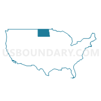
Cass County--Fargo City PUMA, North Dakota
About
Outline

Summary
| Unique Area Identifier | 193686 |
| Name | Cass County--Fargo City PUMA |
| State | North Dakota |
| Area (square miles) | 1,767.90 |
| Land Area (square miles) | 1,764.94 |
| Water Area (square miles) | 2.96 |
| % of Land Area | 99.83 |
| % of Water Area | 0.17 |
| Latitude of the Internal Point | 46.92700330 |
| Longtitude of the Internal Point | -97.25237470 |
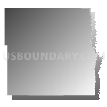
Maps

Graphs
Select a template below for downloading or customizing gragh for Cass County--Fargo City PUMA, North Dakota


Neighbors
Neighoring Public Use Microdata Area (by Name) Neighboring Public Use Microdata Area on the Map
- Clay, Polk, Roseau, Pennington, Marshall, Norman, Kittson & Red Lake Counties PUMA, MN
- East Central North Dakota--Jamestown City PUMA, ND
- Northeast North Dakota--Grand Forks City PUMA, ND
Top 10 Neighboring County (by Population) Neighboring County on the Map
- Cass County, ND (149,778)
- Clay County, MN (58,999)
- Richland County, ND (16,321)
- Barnes County, ND (11,066)
- Traill County, ND (8,121)
- Norman County, MN (6,852)
- Ransom County, ND (5,457)
- Steele County, ND (1,975)
Top 10 Neighboring County Subdivision (by Population) Neighboring County Subdivision on the Map
- Fargo city, Cass County, ND (105,549)
- Moorhead city, Clay County, MN (38,065)
- West Fargo city, Cass County, ND (25,830)
- Horace city, Cass County, ND (2,430)
- Casselton city, Cass County, ND (2,329)
- Oakport township, Clay County, MN (1,797)
- Stanley township, Cass County, ND (1,218)
- Reed township, Cass County, ND (1,175)
- Enderlin city, Ransom County, ND (882)
- Mapleton city, Cass County, ND (762)
Top 10 Neighboring Place (by Population) Neighboring Place on the Map
- Fargo city, ND (105,549)
- Moorhead city, MN (38,065)
- West Fargo city, ND (25,830)
- Horace city, ND (2,430)
- Casselton city, ND (2,329)
- Oakport CDP, MN (1,387)
- Enderlin city, ND (886)
- Mapleton city, ND (762)
- Harwood city, ND (718)
- Kindred city, ND (692)
Top 10 Neighboring Elementary School District (by Population) Neighboring Elementary School District on the Map
Top 10 Neighboring Unified School District (by Population) Neighboring Unified School District on the Map
- Fargo Public School District 1, ND (89,584)
- West Fargo Public School District 6, ND (48,867)
- Moorhead Public School District, MN (42,969)
- Barnesville Public School District, MN (4,455)
- Central Cass Public School District 17, ND (3,783)
- May-Port CG Public School District 14, ND (3,762)
- Kindred Public School District 2, ND (3,559)
- Hillsboro Public School District 9, ND (2,394)
- Northern Cass Public School District 97, ND (2,291)
- Enderlin Area Public School District 24, ND (2,046)
Top 10 Neighboring State Legislative District Lower Chamber (by Population) Neighboring State Legislative District Lower Chamber on the Map
- State House District 9A, MN (42,418)
- State House District 9B, MN (39,347)
- State House District 2A, MN (37,063)
- State House District 27, ND (26,013)
- State House District 22, ND (20,531)
- State House District 13, ND (18,314)
- State House District 46, ND (15,488)
- State House District 41, ND (14,743)
- State House District 45, ND (13,993)
- State House District 21, ND (13,677)
Top 10 Neighboring State Legislative District Upper Chamber (by Population) Neighboring State Legislative District Upper Chamber on the Map
- State Senate District 9, MN (81,765)
- State Senate District 2, MN (76,807)
- State Senate District 27, ND (26,013)
- State Senate District 22, ND (20,531)
- State Senate District 13, ND (18,314)
- State Senate District 46, ND (15,488)
- State Senate District 41, ND (14,743)
- State Senate District 45, ND (13,993)
- State Senate District 21, ND (13,677)
- State Senate District 24, ND (13,443)
Top 10 Neighboring 111th Congressional District (by Population) Neighboring 111th Congressional District on the Map
Top 10 Neighboring Census Tract (by Population) Neighboring Census Tract on the Map
- Census Tract 405, Cass County, ND (23,686)
- Census Tract 301.04, Clay County, MN (6,882)
- Census Tract 103.03, Cass County, ND (6,281)
- Census Tract 102.04, Cass County, ND (6,035)
- Census Tract 103.05, Cass County, ND (5,670)
- Census Tract 205, Clay County, MN (5,626)
- Census Tract 101.08, Cass County, ND (5,501)
- Census Tract 102.01, Cass County, ND (5,433)
- Census Tract 10.01, Cass County, ND (5,417)
- Census Tract 8.02, Cass County, ND (5,167)
Top 10 Neighboring 5-Digit ZIP Code Tabulation Area (by Population) Neighboring 5-Digit ZIP Code Tabulation Area on the Map
- 58103, ND (47,302)
- 56560, MN (40,766)
- 58102, ND (29,850)
- 58104, ND (28,322)
- 58078, ND (26,321)
- 58047, ND (3,560)
- 58105, ND (2,483)
- 58012, ND (2,474)
- 58051, ND (1,458)
- 58027, ND (1,391)